Blog posts filed under ZipScribble Maps

New, Improved Traveling Presidential Candidate Map

Many years ago, when this website was still young, I created a map of all the ZIP codes in the U.S. in numeric order and then wondered about the shortest path through all of them. I dubbed that The Traveling Presidential Candidate Map. Here is an improved version that's interactive and much more efficient than the old one.

An Uncanny Resemblance

A user in a thread on MetaFilter that linked to the US ZIPScribble Map pointed to a drawing that has an uncanny resemblance to the map: Saul Steinberg's Hen. The bloggy thing of course would have been to just take the image from somewhere and put it next to the map to show it. Instead, I asked for permission. You can probably guess how well that worked.

Improved US ZIPScribble Maps, more Countries to Come

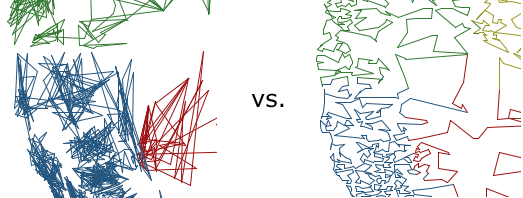
The ZIPScribble Maps of the US obviously hit a nerve, with over 55,000 unique visitors in about two weeks, and more than 70 comments. There was also some criticism, especially regarding some slight problems with coloring the states, and that some of the dividing lines were not, in fact, state lines (and that it was not easy to compare them to state lines). For reasons of convenience, I had also left out Alaska and Hawaii, and there were requests for similar maps for more countries. The US maps have just been updated to solve almost all of the above problems (except for AK and HI, which are included in separate maps for now), and ZIPScribbles for several other countries will be published in the next few days. An interactive version is also in the works.

The Travelling Presidential Candidate Map

While working on the ZIPScribble map, I started to wonder how to untangle the beautifully scribbly lines, and finding the shortest path through all ZIP codes. In computer science, this is called the Travelling Salesman Problem (TSP), and so I decided to make this the Travelling Presidential Candidate Map.